Point cloud to BIM modeling services bridge the gap between the physical reality of an existing building and the intelligent digital model that modern project workflows depend on.
Let’s start with the problem these services solve. Renovation contractors, design teams, and building owners run into it constantly.
You have an existing building. You need to design new work against it, coordinate new systems with what’s already there, or manage the building’s operational assets more effectively. However, for existing conditions documentation, you likely have a set of drawings that are years or decades old. Often, these drawings don’t reflect modifications made over the building’s life. In many cases, they weren’t particularly accurate to begin with.
Designing against that documentation isn’t the same as designing against the real building. Instead, it’s designing against a historical record, with all the gaps, inaccuracies, and outdated information that comes with it. So when the design meets the real building on site, the gap between what the drawings showed and what actually exists turns into problems. As a result, those problems cost money and programme time to resolve.
Point cloud to BIM modeling services solve this. They replace historical documentation with an accurate, current record of the building as it exists right now.
What Point Cloud to BIM Modeling Services Actually Do
The Two Stages of the Process
Point cloud to BIM modeling services combine two distinct processes. Together, these produce the as-built BIM model.
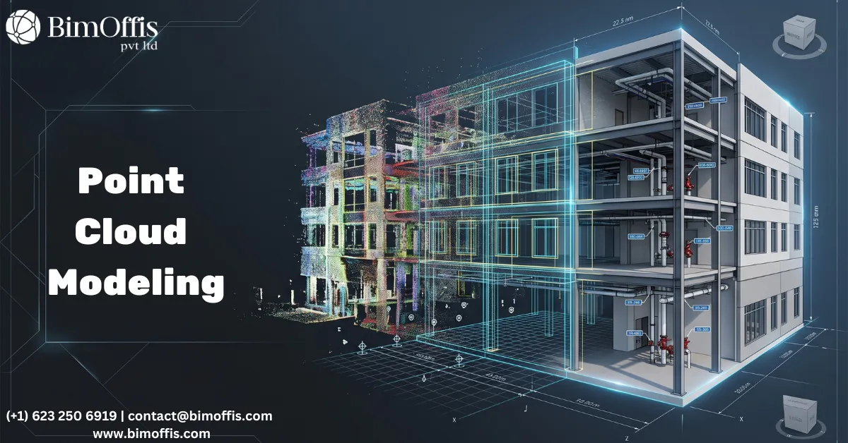
The first stage is laser scanning. First, a 3D laser scanner sits in the existing building and fires laser pulses in every direction from each scanning position. Each pulse then returns distance information about the surface it hit. Gradually, a complete three-dimensional point cloud builds up from multiple scanning positions across the building. In effect, this point cloud is a dense map of millions of data points. It represents every visible surface with millimetre-level accuracy, capturing the raw reality of the building as it currently stands.
The second stage is BIM modeling from the point cloud. Here, modelers work inside the BIM platform with the point cloud as their reference. Essentially, they build intelligent model elements from it. Walls become wall objects with correct layer structures. Similarly, structural elements become correctly classified structural families. MEP systems, in turn, become intelligent system objects with correct connector types and system classifications. In short, the point cloud shows the modelers what’s there, and they translate that into a properly structured BIM model.
Here’s the key distinction: point cloud to BIM modeling services produce an intelligent model, not just geometry. For example, you can query a pipe and find its diameter, material, and system classification. You can also extract a room schedule with accurate areas. Because of this, the model behaves correctly in coordination, scheduling, and documentation workflows. It doesn’t just look right in a 3D view.
Why Accuracy Matters in Point Cloud to BIM Modeling
The Difference Between Accurate and Approximately Accurate
When a project team commissions point cloud to BIM modeling services, they’re investing in accuracy. Every subsequent project decision rests on that accuracy. If it’s compromised, the investment delivers less value, because the design decisions built on the model carry the same uncertainty as the original historical drawings.
Two factors typically compromise accuracy in point cloud to BIM modeling services.
The first is incomplete scanning. Specifically, a point cloud can have gaps in coverage, in areas the scanner couldn’t see because of access limitations or poor scanning positions. Consequently, those gaps carry through into the model. If they fall in areas that matter for the project, the model misleads rather than informs.
The second is modeling quality. Even so, an accurate point cloud doesn’t automatically produce an accurate model. Instead, modelers make decisions about how to represent what the scan shows. Without sufficient expertise or care, those decisions can misrepresent what the point cloud actually shows. For instance, walls might get modeled as simple extrusions instead of correctly layered assemblies. Similarly, MEP elements might get placed approximately rather than at their surveyed positions. And structural elements might get sized to the nearest standard section rather than verified against actual scan dimensions.
So evaluating point cloud to BIM modeling services properly means looking at both scanning quality and modeling quality. A good scan doesn’t automatically produce a good model.
What Point Cloud to BIM Modeling Services Deliver for Different Project Types
Renovation and Retrofit Projects
Renovation and retrofit projects see the most immediate, tangible value from point cloud to BIM modeling services.
The existing conditions model gives the design team a foundation they can trust. For instance, new layout elements sit against the real existing walls, not the drawn ones. Similarly, new MEP services route through the real ceiling void dimensions, not the assumed ones. And new structural elements coordinate with the existing frame as it actually exists today, not as it was documented during original construction.
Conflicts and constraints that would previously surface during construction now appear during design instead, when the team still has the flexibility and budget to fix them properly. The design team can also make decisions with confidence. They no longer need to build in conservative assumptions to cover uncertainty that inaccurate existing conditions information would otherwise create.
MEP Coordination on Existing Buildings
MEP retrofit and systems upgrade projects present a specific version of the existing conditions problem. The available space for new services in ceiling voids, risers, and plant rooms depends on what existing services already occupy those spaces. The connection points for new systems depend on where existing systems and equipment actually sit.
Point cloud to BIM modeling services capture existing MEP infrastructure in enough detail to let new systems coordinate against it before installation. For example, a mechanical engineer routing new chilled water pipework can see exactly what’s in the ceiling void. As a result, they can route the new system through the available space during design, instead of discovering real constraints on site. Likewise, an electrical engineer locating new cable tray runs can verify available space against the model instead of relying on assumptions.
This approach also produces better coordination overall. Designing new MEP systems against an accurate existing conditions model beats designing against original drawings or traditional survey information, because the model captures real three-dimensional spatial relationships. Plain 2D drawings simply can’t support that.
Facilities Management and Asset Management
For building owners and facilities management teams, point cloud to BIM modeling services produce something most buildings lack. They create an accurate, queryable, data-rich record of what the building actually contains and how it’s actually configured.
For instance, equipment appears in the model at its verified installed position with its real dimensional footprint. Similarly, MEP systems show their actual routing, not their designed routing. Structural elements, too, reflect their actual installed positions and profiles. As a result, the facilities management team can query the model directly, so they no longer need to search through paper records and outdated drawings.
Because of this, the practical benefits show up as faster maintenance response, more effective planned maintenance, and better capital planning. Teams also get more reliable planning for future renovation and fit-out work. Over time, each benefit compounds over the building’s operational life, turning the initial investment into an asset that keeps delivering value.
Heritage and Conservation Projects
Heritage buildings present existing conditions challenges that traditional survey methods struggle to handle. Irregular geometry, non-standard construction, and structural fabric that doesn’t follow predictable patterns all make accurate documentation genuinely difficult through conventional means.
Point cloud to BIM modeling services capture the actual geometry of historic building fabric comprehensively and accurately. For example, carved stone profiles, vaulted ceiling geometry, irregular wall surfaces, and deformed structural elements all appear in the point cloud at their real, measured geometry. As a result, the resulting BIM model faithfully represents that real fabric, instead of imposing simplified standard geometry that misrepresents the historic character.
For conservation architects and structural engineers, this accuracy isn’t just convenient. In fact, it’s essential for making properly informed decisions about interventions that affect irreplaceable fabric.
What to Look for in Point Cloud to BIM Modeling Services
Comprehensive Scanning Coverage
The value of point cloud to BIM modeling services starts with how complete the scan is. For example, a scanning programme that only covers easily accessible areas leaves gaps. Often, those gaps sit in the plant rooms, ceiling voids, risers, and hard-to-access spaces where the most important existing conditions information lives.
Therefore, good practice means planning the scanning programme for complete coverage of every area in scope, including the difficult areas. In addition, teams should verify that coverage during scanning, not discover gaps later during modeling.
Modeling Quality and LOD Compliance
The BIM model produced from the point cloud should meet the project’s LOD requirements. Specifically, elements within scope should appear at the specified level of detail, carrying the data the project needs. Before delivery, the team should check modeling quality against the point cloud. Then, they should correct any discrepancies rather than carry them through into the final deliverable.
Clear Communication of Limitations
Good point cloud to BIM modeling services clearly state what the model can and can’t be relied on for. For instance, this includes where scanning coverage was limited, where discrepancies between the scan and original drawings exist, and where the model makes assumptions that need field verification. As a result, this transparency lets the project team decide where they need additional survey work. After all, nobody wants to discover limitations after the design already relies on them.
The Bottom Line
Point cloud to BIM modeling services improve project delivery across renovation, retrofit, MEP coordination, facilities management, and heritage conservation. They do this by replacing historical documentation with accurate, current information about the building as it actually exists.
The investment in accurate existing conditions information pays back on every project decision that rests on it. As a result, teams make better design decisions with confidence. In addition, they face fewer site surprises that cost programme and budget. They also get more reliable coordination between new and existing systems. Meanwhile, facilities management teams gain the ability to work from verified information instead of assumptions.
In short, that’s what point cloud to BIM modeling services deliver. Ultimately, project teams who’ve experienced the difference between designing from accurate existing conditions and designing from historical drawings consistently choose accuracy again on their next project.
Convert your point cloud data into precise BIM models by working with our Point Cloud to BIM specialists for accurate as built documentation.
Frequently Asked Questions from Clients
What are Point Cloud to BIM Modeling Services?
They convert point cloud data into accurate BIM models for existing buildings.
What is a point cloud?
A point cloud is a collection of 3D laser scan data representing existing site conditions.
Why use Point Cloud to BIM Modeling Services?
They improve accuracy, reduce rework, and support renovation and retrofit projects.
Which software is used for Point Cloud to BIM?
Autodesk ReCap, Revit, and Navisworks are commonly used.
Which projects benefit from Point Cloud to BIM?
Renovation, restoration, facility management, and infrastructure projects.
What are the benefits of accurate as built BIM models?
They improve planning, coordination, clash detection, and project execution.